Bothin Marsh - Adaptation Concepts
The Bothin Marsh Open Space Preserve faces unprecedented challenges related to flooding and sea level rise over the next century. One Tam partners, Marin County Parks and Golden Gate National Parks Conservancy, in collaboration through the Evolving Shorelines Project have developed adaptation plans for the Preserve to ensure that the rich habitats and public access trails throughout the site are resilient to future sea level rise using nature-based solutions that enhance the ecosystem and benefit the broader community. Between Fall 2019 and Summer 2021, One Tam partners worked with a multi-disciplinary design team, a Science and Technical Advisory Committee, and the community to develop sea level rise adaptation concepts for the Preserve.
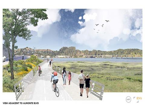
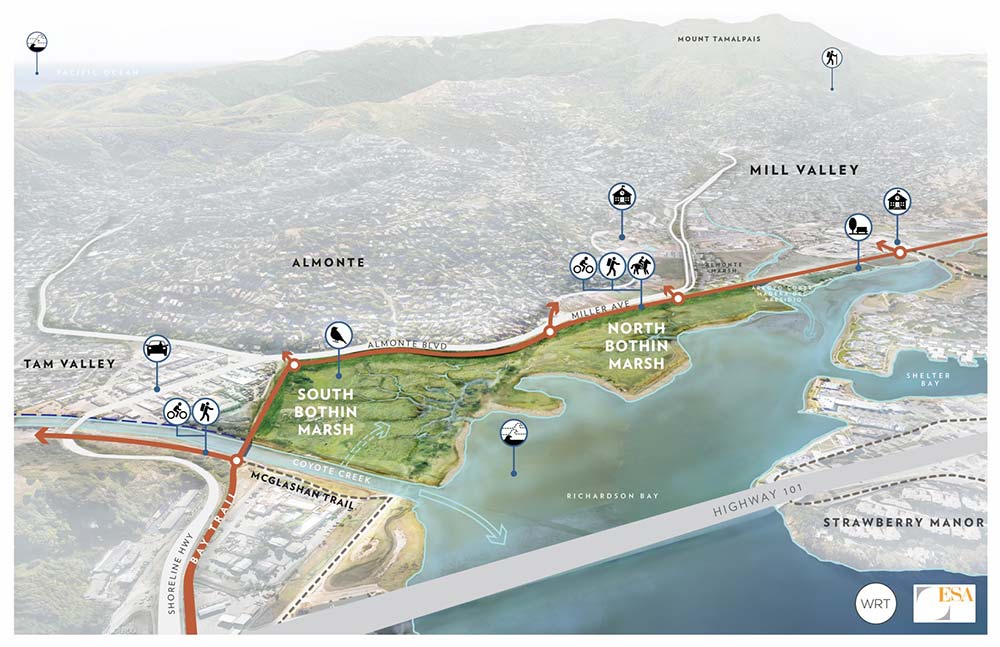
In summary, the planning process resulted in identifying the “Ring the Marsh” concept as the favored approach for the trail alignment which will be developed further in future design documents. The recommended marsh resilience measures include widening the tidal inlet of South Bothin Marsh, vegetation management measures including treatments to reduce or eradicate invasive species and promote desired native vegetation, small-scale earthwork including construction of marsh mounds and small tidal channels, and treatments along the shoreline where wave driven erosion is threatening tidal marsh habitats. To increase the resilience of the tidal marsh habitat at Bothin Marsh to rising sea-levels, we recommend identifying sediment sources suitable for beneficially re-use to increase the elevation of the marsh via delivery approaches like thin-lift placement and mudflat augmentation. Finally, the report identifies opportunities for additional future study of potential flood protection strategies and re-alignment of Coyote Creek to facilitate natural sediment delivery to the marsh.
The Adaptation Concepts Report (full report, including appendices) documents the adaptation planning and design process that will serve as the foundation for future detailed design development. Part 1: Initial Planning Memo includes the community vision, existing conditions overview, sea level rise analysis, and identifies many of the key design measures most appropriate to solving the key challenges on the site. The Initial Planning Memo was originally published June 20, 2020, Part 1 now includes minor updates and revisions.
Part 2: Adaptation Design Concepts and Evaluation illustrates three design concepts and evaluates the benefits and challenges associated with each from the perspective of trail access and connectivity, and the current understanding on the ecological tradeoffs associated with proposed marsh resilience measures. Each concept is evaluated based on values identified by the community and a qualitative assessment by the design team, with input from a Science and Technical Advisory Committee, of the ecological and geomorphic outcomes, and other technical considerations.
· The Adaptation Concepts Report also includes several appendices:
o Appendix 1: Marsh Resilience Memo. This study estimated the potential benefits to tidal marsh habitat resilience for different combinations of channel re-alignment and beneficial sediment re-use measures and for several sea-level rise scenarios.
o Appendix 2: Coyote Creek Hydraulics and Sediment Study. This study evaluated the potential increase in sediment delivery from Coyote Creek to South Bothin Marsh under the re-aligned Coyote Creek scenario. The re-aligned creek channel results in an approximately 60% increase in sediment delivery from the creek to the marsh.
o Appendix 3: Adaptation Concepts Survey Results Memo. This memo documents the process and results of the community Adaptation Concepts Survey which played a key role in the concepts evaluation.
o Appendix 4: Concepts Evaluation Community Presentation – Q&A Response. This document provides detailed responses to the long list of questions received at the June 8, 2021 Community Presentation during which the project team presented our evaluation of the adaptation concepts.